Sechelt, BC V0N 3A0
Canada

|
#201 - 5760 Teredo St
Sechelt, BC V0N 3A0 Canada |

|
|
1772 MAPS SHOW A NORTHWEST COAST OF FANTASY
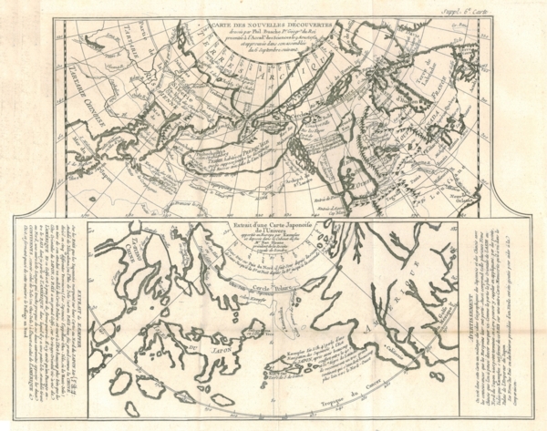
BEFORE ACTUAL EUROPEAN EXPLORATION SECHELT, BC — DECEMBER 2, 2008 — Local real estate agent Gary Little has written the following article relating to a 1772 engraving showing two maps of fantasy relating to the geography of the Pacific Northwest. This is one in a planned series of articles on the history of B.C. to celebrate the sesquicentennial of the founding of the Crown Colony of British Columbia in 1858. The engraving shown here incorporates two intriguing maps of the Pacific Northwest published in 1772 just prior to the first recorded explorations of the area in the last quarter of the 18th century by the European explorers Cook (1778), La Pérouse (1786), Vancouver (1792-4), as well as several Spanish expeditions (1774-1792). Not surprisingly, then, the maps are highly inaccurate and are certainly more entertaining than informative. The two maps have the following titles:

Two maps of fantasy of the Pacific Northwest The upper map, Map of New Discoveries, is based on a map first published by Philippe Buache, Geographer to the King of France, in 1752. Although the eastern coastline of Asia is relatively accurate, the northwest coast of America is pure fantasy. It includes the purported discoveries in 1592 of Juan de Fuca, a Greek naval pilot working for Spain: a huge Sea of the West (Mer de l'Ouest), situated in the heart of present day British Columbia, accessed from the Pacific Ocean through the Entrance of Fuca (Entrée de Fuca). De Fuca claimed to have found a strait at latitude 47°N leading to a large inland sea 20 sailing days distant, but no corroborating evidence of his voyage has ever been found. Nevertheless, the strait (at 48°30'N) separating Vancouver Island from Washington State was named after him when it was spotted in 1787 by Capt. Charles Barkley. Other elements of the map are based on the purely mythical 1640 voyage of Admiral Bartholomew de Fonte, first reported (as fact) in 1708 in The Monthly Miscellany, or Memoirs for the Curious magazine, namely the optimistic system of lakes, rivers, and canals hinting at a navigable route from the Sea of the West to Hudson Bay — in other words, the fabled northwest passage which, by this time, had eluded explorers for 250 years. The lower map is based on an early Japanese map brought to Europe from Japan in 1693 by German naturalist and world traveler Engelbert Kaempfer. After Kaempfer's death in 1716, the map was acquired by Sir Hans Sloane, President of the Royal Society in London. The map shows a rather crude outline of the coast of America north of California. Asia is also grossly misshapen and the islands of Japan are disproportionately large.
This exemplar is from a Supplement to the 1772 edition of Dénis Diderot's Encyclopédie and was created by Didier Robert de Vaugondy. It is a copperplate engraving.
Gary Little is a realtor® and licensed real estate trading services representative in the offices of Royal LePage Sussex in Sechelt, British Columbia, Canada. He is a former senior software marketing manager, having previously worked in Silicon Valley for almost 20 years at the worldwide headquarters of Apple Inc. and Sun Microsystems, Inc. He is well known for his interactive real estate map of the Sunshine Coast (map.garylittle.ca).
CONTACT INFORMATION
Gary Little, realtor® This news release is located online at: http://www.GaryLittle.ca/maps-historic/diderot1772.html |