Sechelt, BC V0N 3A0
Canada

|
#201 - 5760 Teredo St
Sechelt, BC V0N 3A0 Canada |

|
|
FIRST MAP TO USE THE NAME 'BRITISH COLUMBIA'
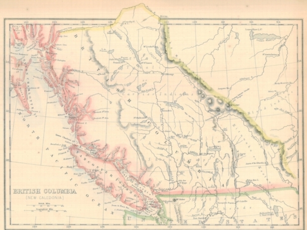
ON DISPLAY IN SECHELT SECHELT, BC — NOVEMBER 13, 2008 — Gary Little has written the following article relating to an 1858 map thought to be the first to use the name "British Columbia". This is one in a planned series of articles on the history of B.C. to celebrate the sesquicentennial of the founding of the Crown Colony of British Columbia in 1858. As we near the actual day marking the 150th birthday of British Columbia, it's a good time to highlight the historic map pictured with this article. It is the very first printed map to use the name "British Columbia" and was first published in a supplement to the Weekly Dispatch newspaper in London just a few weeks after the passing by the English Parliament of "An Act to provide for the Government of British Columbia" on August 2, 1858. This Act — which created the Crown Colony of British Columbia — was later proclaimed in force at Fort Langley on November 19, 1858 (150 years ago next Wednesday) by the first Governor James Douglas.

Map of British Columbia — 1858 The map has a parenthetic subtitle, "New Caledonia". This was the name given to the central interior of the area in 1805 by explorer and fur trader Simon Fraser of the North West Company because the land reminded him of his native Scotland (Caledonia is the ancient Roman name). The name was not adopted for the new colony because it was already used for the island off Australia discovered and named by Capt. James Cook in 1774. The northern border of British Columbia shown on the map is somewhat inaccurate. The 1858 Act stated that the border was to be formed "...by Simpson's River [now called the Skeena], and the Finlay Branch of the Peace River...", that is, to about 57° N. However, the Simpson's River identified on this map actually appears to be the nearby Nass River. Five years later, in 1863, the northern border was extended to the 60th parallel, the present boundary with the Yukon Territory. Another inaccuracy, which will be obvious to residents of the Sunshine Coast, is the absence of Sechelt Inlet. This large body of water was missed (or ignored) by George Vancouver during his 1792 survey of the area. Sechelt Inlet did not begin appearing on maps until it was charted during the 1860 hydrographic survey of the Sunshine Coast led by Capt. George Henry Richards, R.N. aboard the HMS Plumper. Notice that the San Juan Islands are optimistically marked as British territory on this map. Although the southern mainland border along the 49th parallel from the Rockies to the Pacific had been agreed to in 1846, the precise routing of the international boundary through the islands in southern Georgia Strait remained in dispute with the United States The dispute came to a boil in 1859 when the so-called Pig War broke out on San Juan Island but it was not until 1872 that arbitrator Kaiser Wilhelm of Germany imposed the current international boundary, making the San Juan Islands American territory.
An original exemplar of this map, taken from the Weekly Dispatch Atlas of 1863, is in the collection of Gary Little.
This news release is located online at: http://www.GaryLittle.ca/maps-historic/bc1858.html |