Sechelt, BC V0N 3A0
Canada

|
#201 - 5760 Teredo St
Sechelt, BC V0N 3A0 Canada |

|
|
District Municipality of Sechelt: 25th Anniversary
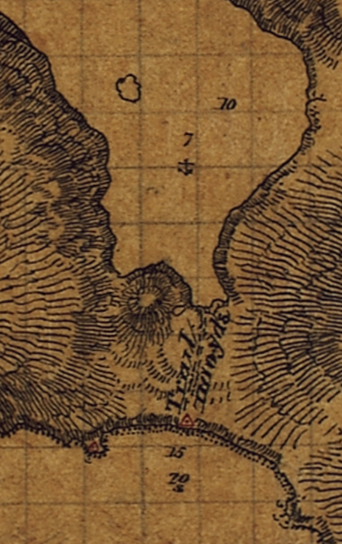
Earliest large-scale map of the Sechelt area (1860). Surveyed by Capt. G.H. Richards. "Trail 1100 yds" between Porpoise Bay and Trail Bay. In honour of this occasion, it seems appropriate to turn back the clock and review the early history of the Sechelt community. First Contact. Prior to 1860, not much was known by Europeans about the area we now call the Sunshine Coast. Spanish and British explorers passed through here in 1791 and 1792 and prepared the first maritime charts but their visits were brief and their descriptions of the area were terse and uninteresting. George Vancouver, for example, complained frequently about the bad weather although he also raved about the "forest trees in great abundance." The next notable visitors arrived in 1860 to prepare more detailed charts of the area in support of safer coastal navigation in the new colony of British Columbia. They included Capt. George Henry Richards and his crew aboard the surveying ship H.M.S. Plumper. They were the first to survey the body of water now known as Sechelt Inlet, including Narrows Inlet and Salmon Inlet, bodies of water that Vancouver had overlooked in 1792. The 1860s also brought the first Catholic missionaries eager to convert the native population. It was these missionaries who insisted — to make religious training more convenient — that the widely dispersed native communities in Jervis Inlet and Sechelt Inlet relocate to the Sechelt area for most of the year. Interaction with the white man was not kind to the Sechelt bands and a smallpox epidemic ravaged them in 1862. By 1876 there were only 167 surviving native residents in Sechelt. The first private landowner in Sechelt was a retired military man, John Scales. He had come to B.C. in 1859 to work on public works projects (roads, bridges, buildings, etc.) as part of Colonel Moody's corps of Royal Engineers. When the corps was disbanded, he did not to return to England and so became entitled to a 150-acre military land grant offered by the colonial government. On May 25, 1869 he formally requested from Chief Commissioner of Land & Works Joseph Trutch all the land from Porpoise Bay to Trail Bay between what are now Shorncliffe and Wharf avenues (District Lots 303 and 304) — in other words, the entire village area of present-day Sechelt. 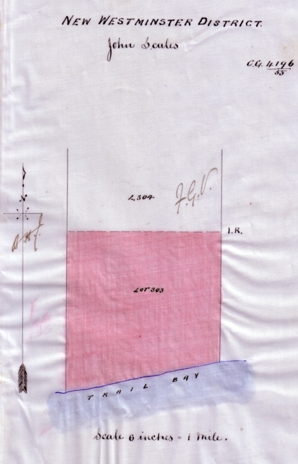 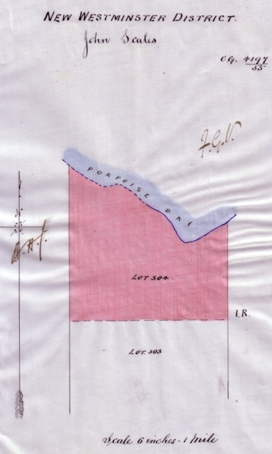
District Lot 303 (150 acres on Trail Bay) & District Lot 304 (110 acres on Porpoise Bay). Crown Grants to John Scales on December 16, 1891. It is unclear what first attracted Scales to the Sechelt area. He never did live on the property. However, he had business connections to Burrard Inlet sawmills suggesting that he may have acquired the property for investment purposes. In fact, Gilbert M. Sproat, a Joint Commissioner of the Indian Reserve Commission, wrote in 1876:
It has been proposed to make a canal through this neck of land for the purpose of enabling saw logs to be brought from Jervis Inlet to the sawmills at Burrards' Inlet without running the risk of towing them 30 or 40 miles in the open Gulf. The proprietors of one of these sawmills have purchased from a former white settler, or holder of a military grant, the best piece of the neck, extending across from gulf to Inlet.
Despite Sproat's statement, it does not appear that Scales ever sold his land to a sawmill. He received legal ownership of District Lots 303 and 304 — his Crown Grant — on December 16, 1891. Shortly thereafter he sold the property to Hugh Nelson, the Lieutenant-Governor of British Columbia. Scales spent the latter part of his life in Nanaimo and died there in 1906. The Cook Family. The first permanent white settlers in Sechelt were Thomas John Cook, his wife Sarah, and infant daughter Ada who arrived on April 5, 1894. In 1891, Cook had pre-empted District Lot 1331, to the immediate west of the Scales land, named it Shorncliffe after an area in Kent, England where Cook had grown up, and this is where he set up the family homestead. Cook received his Crown Grant on January 17, 1895 and afterwards worked for many years as a steward on Canadian Pacific's Empress of India. His granddaughter, Helen Dawe, would later become an avid amateur historian and be responsible for preserving many important records documenting the early history of Sechelt and the Sunshine Coast. 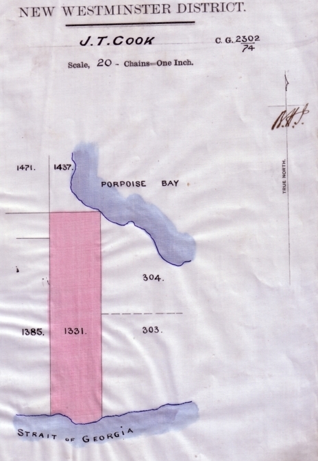
District Lot 1331 ("Shorncliffe"). Crown Grant to Thomas John Cook on January 17, 1895. Bert turned out to be a ball of entrepreneurial energy who, in the course of 30 years, transformed Sechelt into the vibrant commercial centre of the Sunshine Coast. His activities began in earnest in 1895 when he acquired District Lots 303 and 304 from the widow of Hugh Nelson and immediately began to develop this prime real estate. His pace of development was frenetic. On the Trail Bay waterfront alone, he built multiple hotels and general stores over the years, several rental cabins, a wharf, a tea room, and a post office (he was named postmaster on March 1, 1896). He even had a passenger steamship line for a brief time. Bert Whitaker died in 1925 in Vancouver at the age of 50. His commercial property in Sechelt was subsequently snapped up by the Union Steamship Company who managed it until the 1950s in conjunction with the nearby Selma Park resort it had acquired in 1917 from the All Red Line. Of all the buildings that Whitaker erected in Sechelt, only two cottages on Trail Bay remain, Rock Cottage and Green Cottage. In some sense, however, all of present-day Sechelt owes a little to Whitaker's visionary leadership and entrepreneurial spirit in the first quarter of the 20th century.
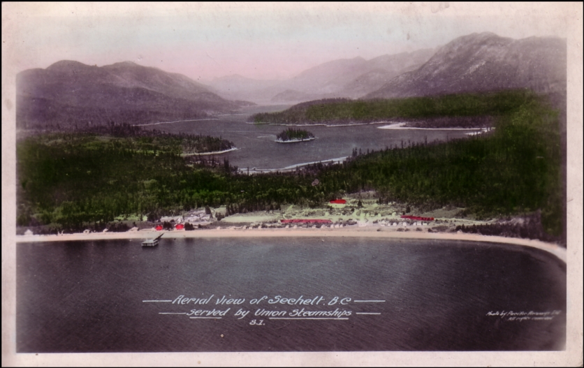
Aerial photograph of Sechelt ca. 1930s. 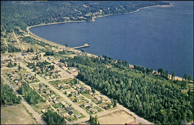
Aerial photograph of Sechelt 1968. Note that the site of the present-day Trail Bay Centre (opened in 1970) is still fully treed. 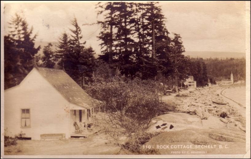
Rock Cottage 1926 — built by Bert Whitaker as a revenue cottage. It is still present on the esplanade near Snickett Park. 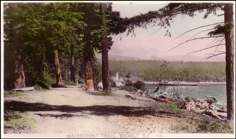
Waterfront trail ca. 1930s. Note the Union Steamship vessel at the wharf. 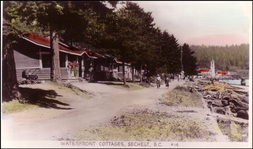
Waterfront cottages ca. 1930s. These were located along The Boulevard in present-day Sechelt. 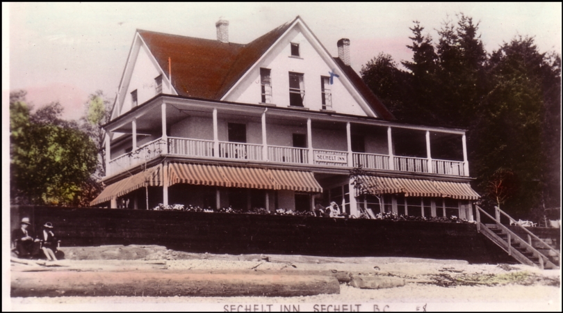
Sechelt Inn 1945 — built in 1906 as the Alfred & Henrietta Whitaker family home. It was destroyed by fire on July 22, 1963. It was located at the site of the present-day Driftwood Inn. 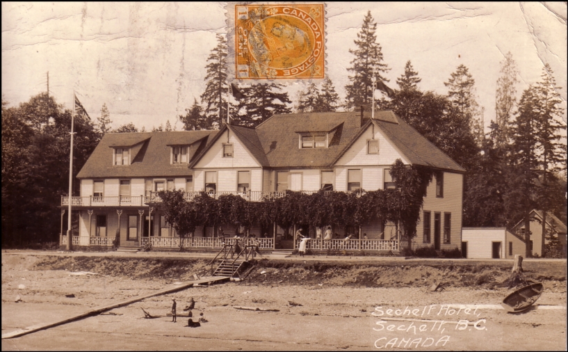
The first Sechelt Hotel — built in 1899. It burned down on June 1, 1914. This postcard was mailed six days before the fire. It was located at the site of the present-day Beach House condominium. 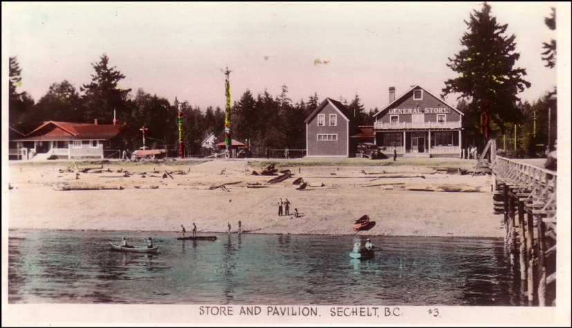
Tea Room / Dance Pavilion, Totem Poles, and General Store ca. 1930s. The General Store was torn down in 1965-66. The Tea Room was built by Bert Whitaker in the early 1920s; the three totems were erected in 1928. These buildings were located at the site of the present-day Royal Terraces and Beach House condominiums. 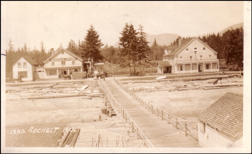
Sechelt General Store / Trail Bay wharf / second Sechelt Hotel ca. 1920s. The hotel was built in 1906 as a store and post office; it burned down on July 26-27, 1936. The hotel was located at the site of the present-day Rotary Friendship Park. 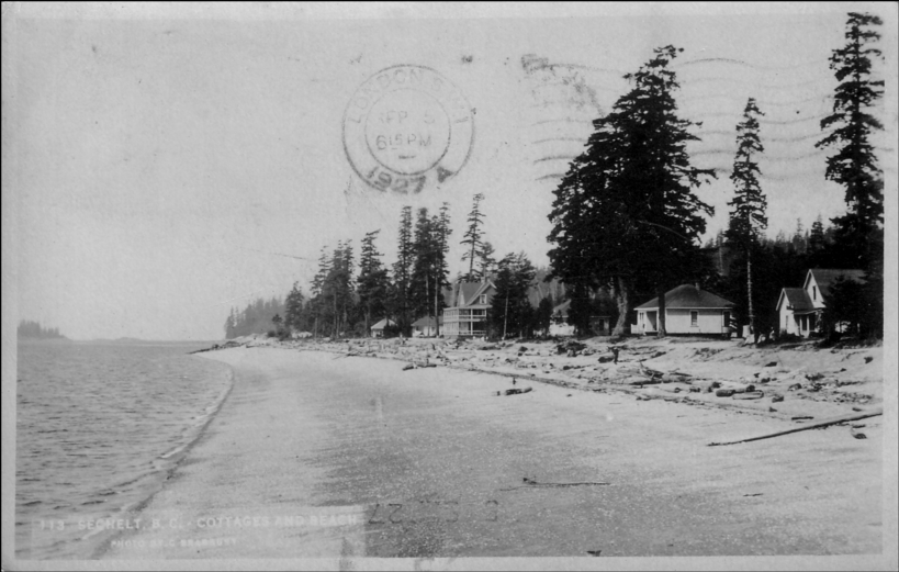
Sechelt waterfront 1927 (looking west). The Whitaker family home (Beach House) is shown at the centre of the photo. ___________ Gary Little is an innovative real estate agent in the offices of Royal LePage Sussex in Sechelt, British Columbia. He is well known for his use of technology to provide compelling real estate tools for the general public, notably his interactive real estate map of the Sunshine Coast (first published in 2006), his real estate statistics service, and his real estate services for mobile phone users. You can contact him through www.GaryLittle.ca.
This news release is located online at: http://www.GaryLittle.ca/history/sechelt25.html |